
Activity 6: Brussels, a city that can be unbreathable... and noisy!

Brussels, Europe's greenest capital?
Activity 6 - Brussels, a sometimes hardly breathable and noisy city!
You've already seen that Brussels is home to a great deal of biodiversity, thanks in particular to the Forêt de Soignes. And you've just seen that several rivers run through the city. However, the presence of trees and watercourses does not prevent Brussels, like many large cities, from becoming a real heat island when temperatures are high. In this chapter, we take a look at the air in Brussels, which is sometimes hardly breathable during heatwaves, and is also polluted by chemical substances. We will also look at noise pollution.
1. Heat islands and coolness islands
A heat island is an urban area where temperatures during hot weather are higher than in the surrounding rural areas. These heat islands are particularly distressing for residents, and can even be fatal for the frail. Observed in all the world's major cities and urbanised areas, heat islands are also present in Brussels.
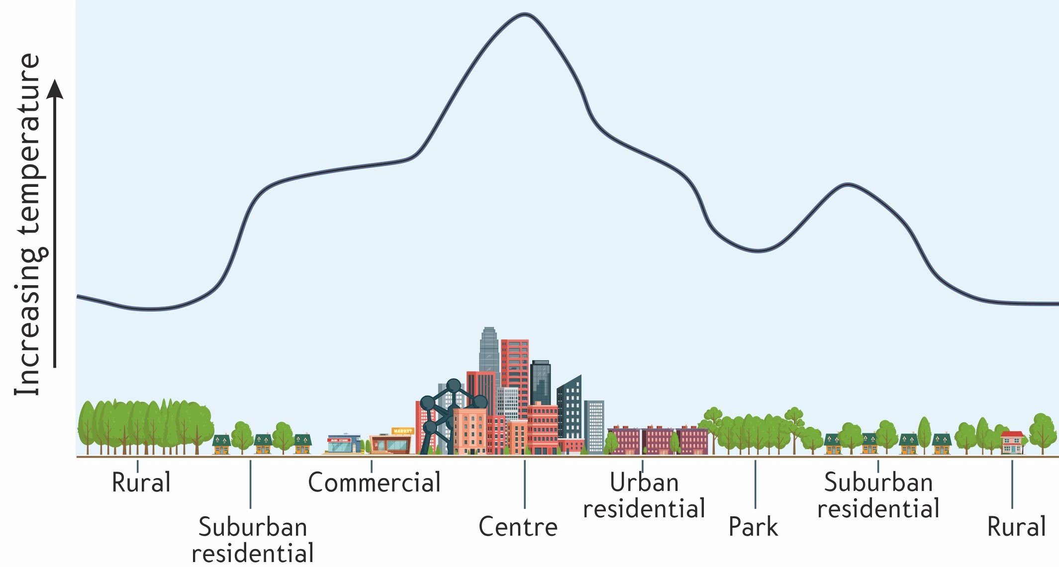
Caption: Illustration of a heat island in an urban environment. Source :Climat : état des lieux | Citoyen - Bruxelles Environnement
There are many causes of these heat islands: soil sealing, lack of plant cover, vertical walls that absorb the sun's rays, dark materials that absorb heat, combustion gas emissions from cars / lorries / buses, hot air discharged by air conditioners, hot water circulating in pipes, etc. Look at the map below, which shows the coolness islands in blue and the heat islands in red.
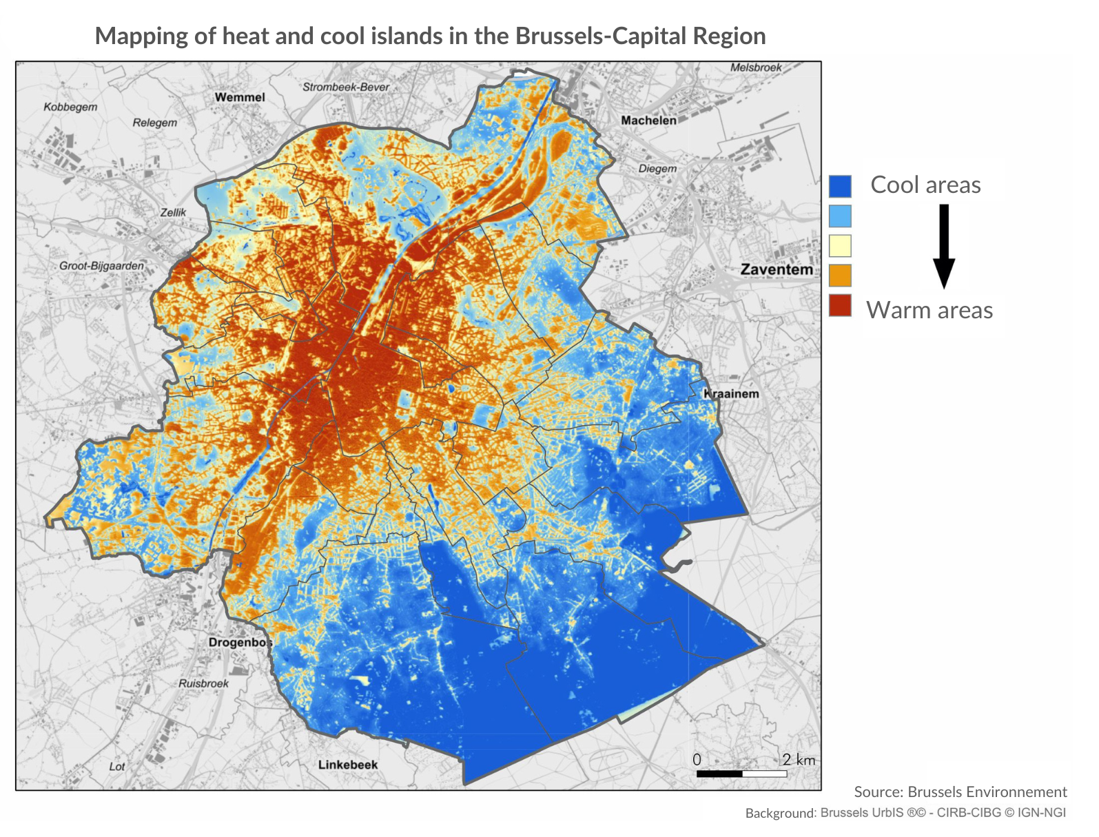
Source: Bruxelles Environnement (2018) Mapping of cool islands in the Brussels-Capital Region. Online.
If we now look at the map of Brussels' population density in 2023, we can see that it is the densest neighbourhoods that are most affected by these heat islands.
Map: Monitoring of the neighbourhoods, population density per neighbourhood in 2023. Online.
The coolest areas, on the other hand, are mainly situated in and around the Forêt de Soignes in the south-east of Brussels, while the city centre and the poor crescent are particularly vulnerable to heatwaves. These areas experience significantly higher temperatures during hot weather, due to the lack of vegetation. Materials such as concrete absorb a great deal of heat and release it throughout the day and night. Vegetated ground, on the other hand, absorbs almost none of the heat, which helps to cool the air, particularly at night. The parts of the city with the least green spaces therefore suffer particularly from the heat in summer. Between 1987 and 2016, there was an average temperature difference of 3°C between the centre of Brussels and the surrounding area, and even 4.5°C for temperatures measured at 11pm during July and August! This has a major impact on the quality of sleep of the people of Brussels, and therefore on their health.
2. Air quality
While it can be very hot in Brussels in summer, the air can also become unbreathable all year round, not because of the temperatures, but because of pollution.
3. Noisy city
You saw in Section 4 that Brussels is a very congested city. This traffic generates a large amount of air pollution, but it also causes noise pollution. In Brussels, the main source of noise pollution in terms of the number of Brussels residents affected is road traffic. Bruxelles Environnement estimated that Between 2016 and 2020, the sleep of 3 out of 4 Brussels residents was disturbed by road traffic noise, and 1 in 10 by air traffic noise. In total, almost 80% of the population of Brussels is affected by noise above the threshold of 45 db(A), which is considered to be harmful to restful sleep.
Air traffic due to the proximity of Brussels airport gets a lot of media coverage, but it is not the main source of noise pollution for the majority of Brussels residents. It does, however, particularly affect certain densely populated neighbourhoods and the north of Brussels, as we will come back to later. Other sources of noise in Brussels are related to public transport, railways, installations (refrigerators, air conditioning, etc.) and neighbours (cafés, restaurants, discotheques, etc.).
A noise map of Brussels has been developed based on modelling and shows the noise levels of each street according to its location. Move your mouse over the map to hear the noise (don't forget to activate the sound!).
Legend: Map of multiple exposure to road, air and rail transport noise in the Brussels-Capital Region - Lden indicator (2016). Sources: Bruxelles Environnement, 2018 based on ASM Acoustics & Stratec, 2018, CadnaA modelling software. Noise: the state of play | Citoyen - Brussels Environment
Ready to test your knowledge of the air in Brussels? Below are a few questions to test you!
Do you have a suggestion, comment, remark about this activity? Click here!

